Deviation Actions


![Thedas World Map [Dragon Age]](https://images-wixmp-ed30a86b8c4ca887773594c2.wixmp.com/f/5ea9225d-d795-4a75-a4c6-d0c98067b02f/daazbgg-2b2c57d7-2aef-4c78-93bc-7a2d5c82c7aa.jpg/v1/crop/w_184,h_184,x_15,y_0,scl_0.036726546906188,q_70,strp/thedas_world_map__dragon_age__by_martynasb_daazbgg-92s-2x.jpg?token=eyJ0eXAiOiJKV1QiLCJhbGciOiJIUzI1NiJ9.eyJzdWIiOiJ1cm46YXBwOjdlMGQxODg5ODIyNjQzNzNhNWYwZDQxNWVhMGQyNmUwIiwiaXNzIjoidXJuOmFwcDo3ZTBkMTg4OTgyMjY0MzczYTVmMGQ0MTVlYTBkMjZlMCIsIm9iaiI6W1t7ImhlaWdodCI6Ijw9NTAxMCIsInBhdGgiOiJcL2ZcLzVlYTkyMjVkLWQ3OTUtNGE3NS1hNGM2LWQwYzk4MDY3YjAyZlwvZGFhemJnZy0yYjJjNTdkNy0yYWVmLTRjNzgtOTNiYy03YTJkNWM4MmM3YWEuanBnIiwid2lkdGgiOiI8PTY2ODAifV1dLCJhdWQiOlsidXJuOnNlcnZpY2U6aW1hZ2Uub3BlcmF0aW9ucyJdfQ.7vSiXmFP1scjPt8qaAduSo1rM60fYmROhkvbVYD0_5M)
![Thedas World Map [Dragon Age]](https://images-wixmp-ed30a86b8c4ca887773594c2.wixmp.com/f/5ea9225d-d795-4a75-a4c6-d0c98067b02f/daazbgg-2b2c57d7-2aef-4c78-93bc-7a2d5c82c7aa.jpg/v1/crop/w_92,h_92,x_8,y_0,scl_0.018363273453094,q_70,strp/thedas_world_map__dragon_age__by_martynasb_daazbgg-92s.jpg?token=eyJ0eXAiOiJKV1QiLCJhbGciOiJIUzI1NiJ9.eyJzdWIiOiJ1cm46YXBwOjdlMGQxODg5ODIyNjQzNzNhNWYwZDQxNWVhMGQyNmUwIiwiaXNzIjoidXJuOmFwcDo3ZTBkMTg4OTgyMjY0MzczYTVmMGQ0MTVlYTBkMjZlMCIsIm9iaiI6W1t7ImhlaWdodCI6Ijw9NTAxMCIsInBhdGgiOiJcL2ZcLzVlYTkyMjVkLWQ3OTUtNGE3NS1hNGM2LWQwYzk4MDY3YjAyZlwvZGFhemJnZy0yYjJjNTdkNy0yYWVmLTRjNzgtOTNiYy03YTJkNWM4MmM3YWEuanBnIiwid2lkdGgiOiI8PTY2ODAifV1dLCJhdWQiOlsidXJuOnNlcnZpY2U6aW1hZ2Uub3BlcmF0aW9ucyJdfQ.7vSiXmFP1scjPt8qaAduSo1rM60fYmROhkvbVYD0_5M)


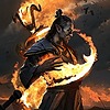
![Tamriel Map [The Elder Scrolls Universe]](https://images-wixmp-ed30a86b8c4ca887773594c2.wixmp.com/f/5ea9225d-d795-4a75-a4c6-d0c98067b02f/d7c8zpx-578fef31-2335-40be-b78f-ba0d832967f3.jpg/v1/crop/w_184,h_184,x_21,y_0,scl_0.055255255255255,q_70,strp/tamriel_map___the_elder_scrolls_universe__by_martynasb_d7c8zpx-92s-2x.jpg?token=eyJ0eXAiOiJKV1QiLCJhbGciOiJIUzI1NiJ9.eyJzdWIiOiJ1cm46YXBwOjdlMGQxODg5ODIyNjQzNzNhNWYwZDQxNWVhMGQyNmUwIiwiaXNzIjoidXJuOmFwcDo3ZTBkMTg4OTgyMjY0MzczYTVmMGQ0MTVlYTBkMjZlMCIsIm9iaiI6W1t7ImhlaWdodCI6Ijw9MzMzMCIsInBhdGgiOiJcL2ZcLzVlYTkyMjVkLWQ3OTUtNGE3NS1hNGM2LWQwYzk4MDY3YjAyZlwvZDdjOHpweC01NzhmZWYzMS0yMzM1LTQwYmUtYjc4Zi1iYTBkODMyOTY3ZjMuanBnIiwid2lkdGgiOiI8PTQ4NjMifV1dLCJhdWQiOlsidXJuOnNlcnZpY2U6aW1hZ2Uub3BlcmF0aW9ucyJdfQ.iZ3rrFHu_TbI4jDCmJJVMRFmEMb0Zuh4HJz0yoHWPuc)
![Tamriel Map [The Elder Scrolls Universe]](https://images-wixmp-ed30a86b8c4ca887773594c2.wixmp.com/f/5ea9225d-d795-4a75-a4c6-d0c98067b02f/d7c8zpx-578fef31-2335-40be-b78f-ba0d832967f3.jpg/v1/crop/w_92,h_92,x_11,y_0,scl_0.027627627627628,q_70,strp/tamriel_map___the_elder_scrolls_universe__by_martynasb_d7c8zpx-92s.jpg?token=eyJ0eXAiOiJKV1QiLCJhbGciOiJIUzI1NiJ9.eyJzdWIiOiJ1cm46YXBwOjdlMGQxODg5ODIyNjQzNzNhNWYwZDQxNWVhMGQyNmUwIiwiaXNzIjoidXJuOmFwcDo3ZTBkMTg4OTgyMjY0MzczYTVmMGQ0MTVlYTBkMjZlMCIsIm9iaiI6W1t7ImhlaWdodCI6Ijw9MzMzMCIsInBhdGgiOiJcL2ZcLzVlYTkyMjVkLWQ3OTUtNGE3NS1hNGM2LWQwYzk4MDY3YjAyZlwvZDdjOHpweC01NzhmZWYzMS0yMzM1LTQwYmUtYjc4Zi1iYTBkODMyOTY3ZjMuanBnIiwid2lkdGgiOiI8PTQ4NjMifV1dLCJhdWQiOlsidXJuOnNlcnZpY2U6aW1hZ2Uub3BlcmF0aW9ucyJdfQ.iZ3rrFHu_TbI4jDCmJJVMRFmEMb0Zuh4HJz0yoHWPuc)


Description
This is an hypothetical map of Tamriel, the Elder Scrolls continent, at the year 1E241.
It represent the territories of the different nations
- In Pink, the First Nord Empire (steered by the High King Vrage the Gifted), with the Nords of Skyrim, the freed Bretons of Highrock, the freed Humans of Cyrod, and the occupied territory of Chimeris.
- In Yellow, the alliance of the Aldmeri Dominion and the declining Direnni Clan. The Aldmeri Dominion groups the Aldmers of the Summerset Islands, the Bosmers of the old Vallenwood, and the Khajiits, probably enslaved of the occupied territory of Pellitine, and the Direnni Clan controling the Iliac Bay Coasts.
- In White, the declining Ayleidoon of the Ayleids of Cyrod (also called Heartland High Elves), It groups also the Ayleids and some other minorities, like Bosmer, and slaves (Human and probably Khajiits in Anequina) The Ayleidoon face two ennemis, a Human rebellion steered by a young human slave named Alessia, and a Nord invasion from Skyrim.
- In Green, the Argonian territory, Argonia. Some Ayleids settlement encroaches the West of Argonia.
- In Purple, the Chimer Territory, Resdayn. The Chimer undergo a Nordic invasion, and are constantly in conflicts with the Dwemer.
- In Orange, the surface territory under Dwemer authority.
in other color : Red for Yokuda, populated with Redguards, in Gray the Orc Kingdom of Orsinium, and in Brown, native Man-beast lands in the futur Hammerfell.
I use my imagination and the known words of the different languages of Tamriel in order to translate some city's name.
It is my own interpretation after many hours playing the Elder Scrolls Games and DLCs, and using all official and unoffical information on the web
-> I used Gimp and Inkscape
Credits : Bethesda Softworks ^^
I'm open for any suggestion and comments ^^