Deviation Actions


![Thedas World Map [Dragon Age]](https://images-wixmp-ed30a86b8c4ca887773594c2.wixmp.com/f/5ea9225d-d795-4a75-a4c6-d0c98067b02f/daazbgg-2b2c57d7-2aef-4c78-93bc-7a2d5c82c7aa.jpg/v1/crop/w_184,h_184,x_15,y_0,scl_0.036726546906188,q_70,strp/thedas_world_map__dragon_age__by_martynasb_daazbgg-92s-2x.jpg?token=eyJ0eXAiOiJKV1QiLCJhbGciOiJIUzI1NiJ9.eyJzdWIiOiJ1cm46YXBwOjdlMGQxODg5ODIyNjQzNzNhNWYwZDQxNWVhMGQyNmUwIiwiaXNzIjoidXJuOmFwcDo3ZTBkMTg4OTgyMjY0MzczYTVmMGQ0MTVlYTBkMjZlMCIsIm9iaiI6W1t7ImhlaWdodCI6Ijw9NTAxMCIsInBhdGgiOiJcL2ZcLzVlYTkyMjVkLWQ3OTUtNGE3NS1hNGM2LWQwYzk4MDY3YjAyZlwvZGFhemJnZy0yYjJjNTdkNy0yYWVmLTRjNzgtOTNiYy03YTJkNWM4MmM3YWEuanBnIiwid2lkdGgiOiI8PTY2ODAifV1dLCJhdWQiOlsidXJuOnNlcnZpY2U6aW1hZ2Uub3BlcmF0aW9ucyJdfQ.7vSiXmFP1scjPt8qaAduSo1rM60fYmROhkvbVYD0_5M)
![Thedas World Map [Dragon Age]](https://images-wixmp-ed30a86b8c4ca887773594c2.wixmp.com/f/5ea9225d-d795-4a75-a4c6-d0c98067b02f/daazbgg-2b2c57d7-2aef-4c78-93bc-7a2d5c82c7aa.jpg/v1/crop/w_92,h_92,x_8,y_0,scl_0.018363273453094,q_70,strp/thedas_world_map__dragon_age__by_martynasb_daazbgg-92s.jpg?token=eyJ0eXAiOiJKV1QiLCJhbGciOiJIUzI1NiJ9.eyJzdWIiOiJ1cm46YXBwOjdlMGQxODg5ODIyNjQzNzNhNWYwZDQxNWVhMGQyNmUwIiwiaXNzIjoidXJuOmFwcDo3ZTBkMTg4OTgyMjY0MzczYTVmMGQ0MTVlYTBkMjZlMCIsIm9iaiI6W1t7ImhlaWdodCI6Ijw9NTAxMCIsInBhdGgiOiJcL2ZcLzVlYTkyMjVkLWQ3OTUtNGE3NS1hNGM2LWQwYzk4MDY3YjAyZlwvZGFhemJnZy0yYjJjNTdkNy0yYWVmLTRjNzgtOTNiYy03YTJkNWM4MmM3YWEuanBnIiwid2lkdGgiOiI8PTY2ODAifV1dLCJhdWQiOlsidXJuOnNlcnZpY2U6aW1hZ2Uub3BlcmF0aW9ucyJdfQ.7vSiXmFP1scjPt8qaAduSo1rM60fYmROhkvbVYD0_5M)


Description
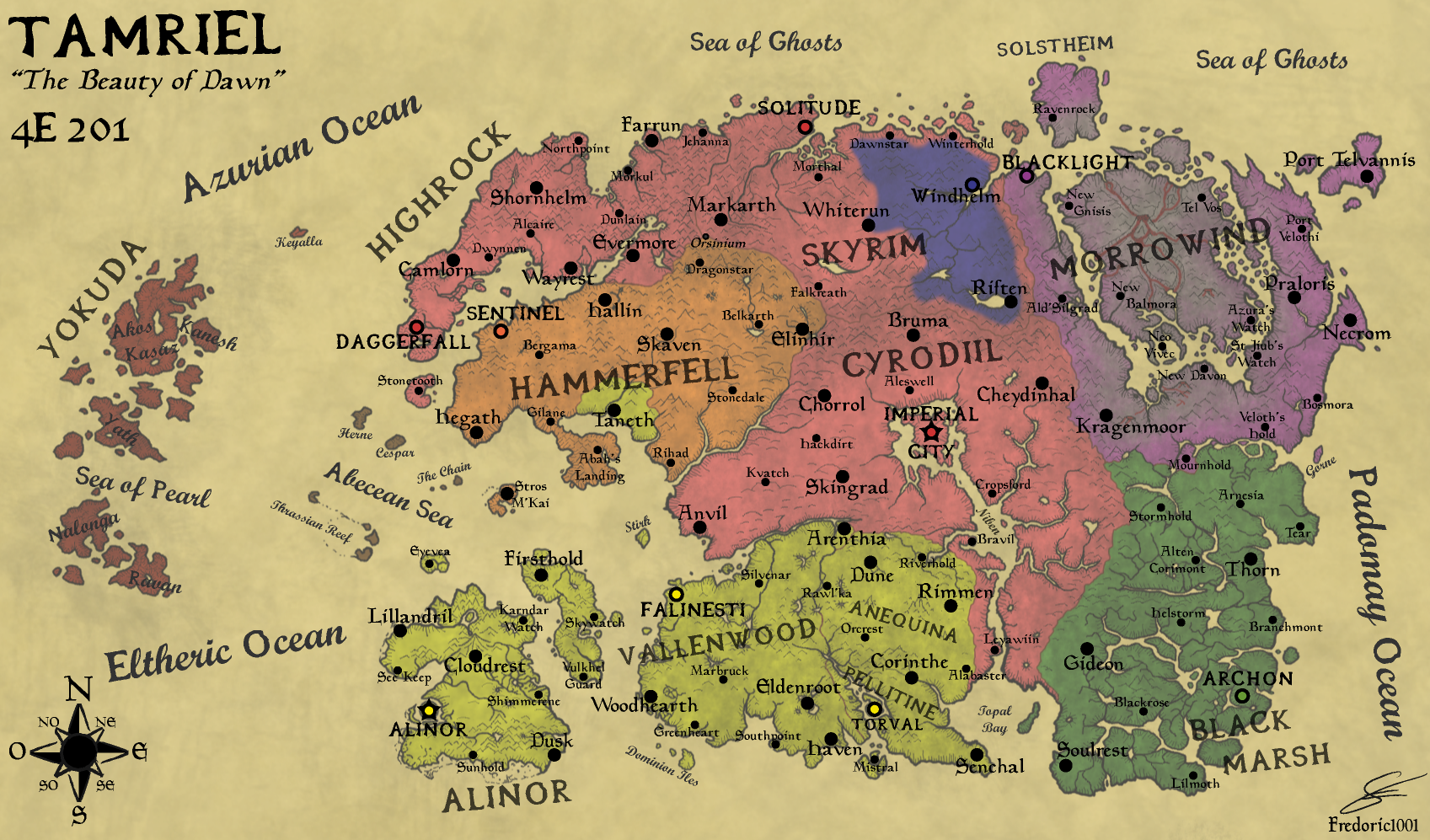
This is the map of Tamriel, the Elder Scrolls continent, at the year 4E201.
(Version Française : fredoric1001.deviantart.com/ar…)
It represent the territories of the different nations
- In Pink, the Human Empire (steered by Titus Mede II), with the Imperials of Cyrodiil, the Nords of Skyrim, and the Bretons of Highrock.
- In Yellow, the Aldmeri Dominion, with the Aldmers of the Summerset Islands, the Bosmers of Vallenwood, and the Khajiits of Elsweyr.
- In Orange, the Redguard Kingdom of Hammerfell
- In Green, the Argonian State in Black Marsh
- In Purple, the Dunmer Territories in the devasted Morrowind province
And in blue, the Stormcloak's rebelion Territory (steered by Ulfric Stormcloak)
in other color : Red for Yokuda, partially populated with Redguards, and grey for the devasted lands of Vvardenfell ![]()
It is my own interpretation after many hours playing the Elder Scrolls Games and DLCs, and using all official information on the web, and using some imagination too ^^
-> I used Gimp and Inkscape
Credits : Bethesda Softworks ^^
I'm open for any suggestion and comments ^^
And after the Skyrim Civil War, Skyrim and High Rock will declare independence from the Empire.